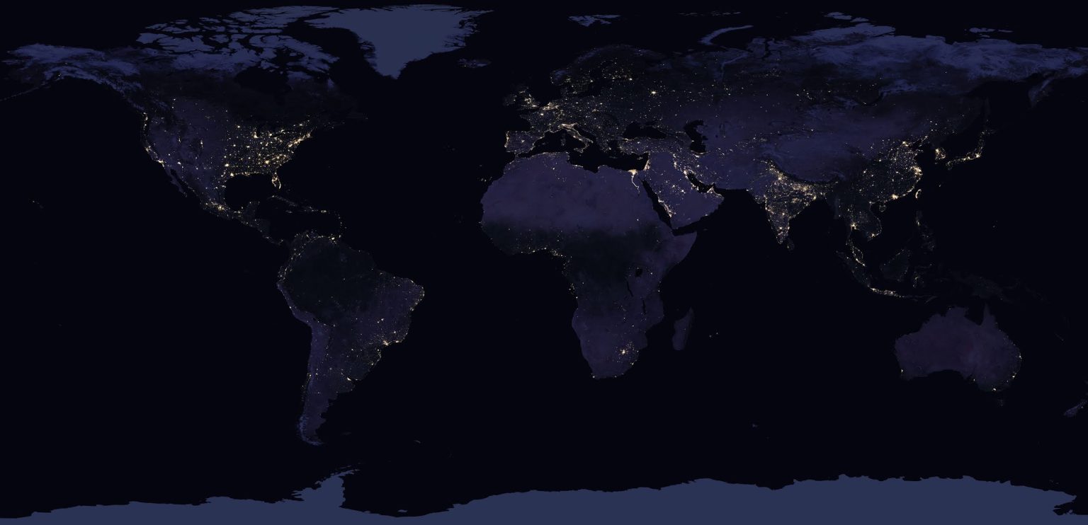
This image of the Earth at night can teach us a lot.

Obviously, a lot of these dots are cities, but you can even spot entire regions that are more densely populated.


In Europe, the Benelux region and the Po Valley are zones with significant light pollution.

In Africa, one can clearly trace the path of the Nile River.

In Saudi Arabia, oil extraction produces bright lights as a result of gas flaring.

In the mostly uninhabited regions of Western Australia, the satellites could capture light from wildfires that occurred over a span of 22 days.

At the waters surrounding South Korea, the numerous fishing boats emit bright lights. There exist agreements between countries that regulate fishing, which can result in unusual shapes such as these perfectly straight lines.
North Korea has minimal nighttime lights primarily due to its limited electricity network and economic challenges. This results in widespread power outages and restricted access to electricity. Interestingly, this low light pollution makes North Korea an excellent location for stargazing and astronomy.

Moving to South America, the bright lights of São Paulo and Buenos Aires stand out, highlighting these major urban centers. In contrast, the Amazon rainforest remains dark, revealing its enormous expanse.

In North America, the densely populated East Coast is a continuous stretch of light from Boston to Washington, D.C. The bright lights of Las Vegas are also prominent, surrounded by the dark expanse of the Nevada desert.

In India, the Ganges River basin is illuminated, demonstrating the region’s high population density. The contrast between the bright cities and the dark Himalayan region to the north is striking.

In the Middle East, the lights of Tel Aviv-Jaffa, Beirut, Damascus, and Amman stand out, as do the lights of Palestinian cities such as Gaza and Ramallah, highlighting the region’s dense population and urban areas. Data were collected prior to the destruction of civilian infrastructure during the 2023-2024 Gazan genocide.

In Japan, the lights of Tokyo and Osaka are clearly visible, showcasing the country’s urban concentration. In China, the eastern seaboard is a blaze of light, reflecting the country’s rapid urbanization and industrialization. The difference between the illuminated coastal cities and the darker, less populated western regions is quite stark.
Get a print or an wood block with this image!
To create this images, the data used was a global composite of nighttime observations made in 2016 using the Suomi NPP VIIRS (Visible Infrared Imaging Radiometer Suite) satellite instrumentation. This data is publicly available and falls under public domain since April 2017.


