This map portrays a fully terraformed Mars, labeling its reshaped geology with both official IAU names and new labels inspired by human emotions and sensations.

▿ explore and zoom below ▿
maximizing viewer screen is recommended! ☒

The Western Hemisphere is dominated by the Tharsis Region, which includes Olympus Mount—the highest point on Mars and in the Solar System—and the Tharsis Volcanic Range with its three aligned giants: Arsia, Pavonis, and Ascraeus. Just downstream of the glaciers, the landscape is split by a once-ancient gigantic canyon now filled by the Marineris River. Further inland, the terrain sparkles with circular lakes and the Argyre Sea, formed in old impact craters.

The Eastern Hemisphere opens onto the broad Utopia Ocean in the north, with the Isidis Gulf and Elysium Sea scalloping its southern edge. The smooth Hesperia Plain fills the mid-latitudes, rising into the Syrtis Highlands at one side on the equator and the Cimmeria Land on the other. Centered at 50º south, the Hellas Sea sits in a giant basin; its curved shoreline carves the land into a bold crescent.

On a terraformed Mars, oceanic currents would forge new routes beneath a denser atmosphere and redistributed water. Aeolis Cold flows from the northern basin southward, meeting Meridiani Warm along equatorial highs. Their convergence spawns persistent eddies framing Valles Marineris’s submerged channels. Such circulation could concentrate nutrients, creating oases for marine life.

A Martian sol lasts 24.6 hours, so the daily rhythm is nearly identical to Earth’s, but its 669-sol year extends seasons to 6 months rather than 3 as on Earth. Thanks to a 1-bar, Earth-style air mix with 21% oxygen, stable liquid oceans, and about 1000 mm of annual rain, the surface supports familiar weather cycles and fertile soils. An artificial dipole magnetosphere and ozone layer keep UV levels in check, while solar irradiance—about 43% of Earth’s—fuels plant growth and weather. Surface temperatures average around 15 °C. With 0.38 g of gravity instead of 1 g on Earth, objects and bodies feel less than half as heavy, giving the feet a light, springy feel. This also leads to a number of health issues that can be lessened with extensive exercise. Together these traits make a terraformed Mars feel both vividly alien and surprisingly familiar.

Martian plants tower above their Earth counterparts: Martian oaks reach up to 80 m and polar pines climb to 120 m, while Terran trees stay below 40 m. Animals show slender gigantism—a gracile elephant stands 4.5 m tall but weighs 2 500 kg, versus an African elephant at 3.3 m and 6 000 kg. Aquatic species mirror this trend: the amphibious orca grows to 4 m yet weighs 2 000 kg, thanks to buoyant, Earth-like seas under lower gravity. Even small creatures, from the 20 cm megant to 4 m octopoids, outsizing their Terran analogs, reflect a Martian biome shaped by 0.38 g and a thick, life-friendly atmosphere.
 Here’s a nugget that jumps off the cross-section of Tharsis: the bulge’s western escarpment plunges nearly 6 km over just 1 000 km of longitude, while its eastern flank slopes gently for over 3 000 km before blending into the Martian plains. That dramatic asymmetry hints at how the immense volcanic load flexed and fractured Mars’s lithosphere unevenly—driving the formation of Valles Marineris on the steeper side and forging smoother plains where the ground could creep more readily.

Valles Marineris is reborn as the Marineris River, a 4,000 km waterway tumbling 7 km into Mars’s northern plains. Along its sheer walls, waterfalls billow vast steam veils. The low Martian gravity turns every cascade into a permanment cloud.

Aonia Terra’s broad southern highlands hide networks of sinuous gullies that frost over each dawn, hinting at surprising microclimates. Just beyond, the South Polar Cup swells nearly a kilometer thick, its concentric bands trapping dust and pollen build a new ecosystem.
 The Hellas Sea laps the eastern shore of Noachis Rugged Land, the region’s main continent. The sea would fill Mars’s deepest impact basin—down to roughly –8.2 km below datum—creating a vast inland sea whose circulation is shaped by two primary, speculative currents driven by simple hydrodynamic models.These currents would redistribute sediments and help moderate local climates.

The Cimmeria Land map reveals a rugged highland plateau punctuated by ancient river valleys snaking toward deep, terraced basins, while isolated impact craters speckle the landscape. Three regions of the magnetized crust exhibit luminous crustal magnetic zones, which are hotspots with nearly constant green and blue auroras in the sky.

The Northern Ice Cap map unfurls a network of narrow fjords carving deep into the polar plateau, fringed by the Boreum Glacier’s sprawling tongue and dotted with islands like Korolev and the Cotton Archipelago. Drifting icebergs, shaped by the Olympus Current, weave between the Ice Cream Islands.

This timeline lays out a 500-year plan to transform Mars into an Earthlike world. In the first 50 years, orbital mirrors and perfluorocarbon factories warm the polar caps, releasing CO₂ to lift the atmosphere to about 100 mbar. By year 100, plasma stations at Sol-Mars L1 and on Low Mars Orbit combine strenght to create a magnetic shield to halt atmospheric escape. By year 150 further greenhouse gas injections plus ammonia from redirected asteroids boost pressure to 300 mbar and seed nitrogen. Mid-timeline cometary ice impacts and aquifer tapping form transient seas, engineered cyanobacteria fix nitrogen and produce oxygen to reach 0.5 bar by year 250, a microbial biosphere enriches soils and pushes O₂ to 10% by year 400, and by year 500 Mars enjoys 1 bar pressure, 21% oxygen, a stable water cycle, and human-safe UV levels.

This diagram shows two plasma‐ring stations—one stationed at the Sol–Mars L1 point and the other in low Mars orbit—working together to generate an artificial magnetotail that deflects solar wind. Each station’s superconducting rings sculpt a stable magnetosheath and magnetopause around Mars, powered by compact fusion reactors. Combining multiple orbit stations is the most energy-efficient approach, delivering maximal shielding per gigawatt of drive power compared to any single‐station design.

A Phobos Ecopolis functions as a high-efficiency, closed-loop habitat supporting permanent orbital habitation and interplanetary logistics. Its infrastructure integrates gravitational research hubs, cultural archives, and deep-space launch arrays. The mining shafts extract isotopes, rare metals, and cryogenic volatiles from regolith strata, fueling Jovian expeditions and next-generation orbital megastructures. Mars is no longer a destination—it’s home; Phobos is a gateway.

A spacehook on Deimos could act as a low-energy orbital tether, using the moon’s tiny gravity to loft payloads between Mars orbit and deep space with minimal propellant. The Dustsea Pit Quarry exposes rich regolith layers laden with water ice and metals, perfect for in-situ resource extraction to fuel habitats, fuel production, and construction.

If we’re going to have another planet, we’ll follow a two-year cycle that will become the most important rhythm in our civilization for centuries to come.

It’s curious that the Moon measures about half Mars’s diameter, and Mars in turn is roughly half Earth’s; yet the Moon’s surface spans only about 7% of Earth’s (compared to Mars’s 28%), and surface gravity climbs from 0.16 g on the Moon to 0.38 g on Mars and 1 g on Earth.

Since its founding in 2080, the Mars Federation has evolved into a union of 12 planetary states, home to 223 million citizens—all served by a 600 TWh/year energy grid powered by sustainable solar arrays. Its export economy anchored in rare minerals and advanced biotech drives interplanetary trade. The federation’s flag [merch available!], rendered in red, green, and blue and accented by two white crescents, symbolizes an alliance that honors Mars’s mineral heritage and celebrates humanity’s gift of life and breathable air.

Get your HD posters and prints at the links below:
By blending official nomenclature with emotional descriptors, this map invites viewers to imagine Mars as a living world shaped by both science and human creativity. It serves as a reminder of our capacity to dream big.
Finally, this is the first project in which Fabián Ignacio Hualpa, a team member of The Celestial Zoo, actively participated and assisted in naming the new geology. Fantastic job, Fabián and team!
Related Work:
Map of Mars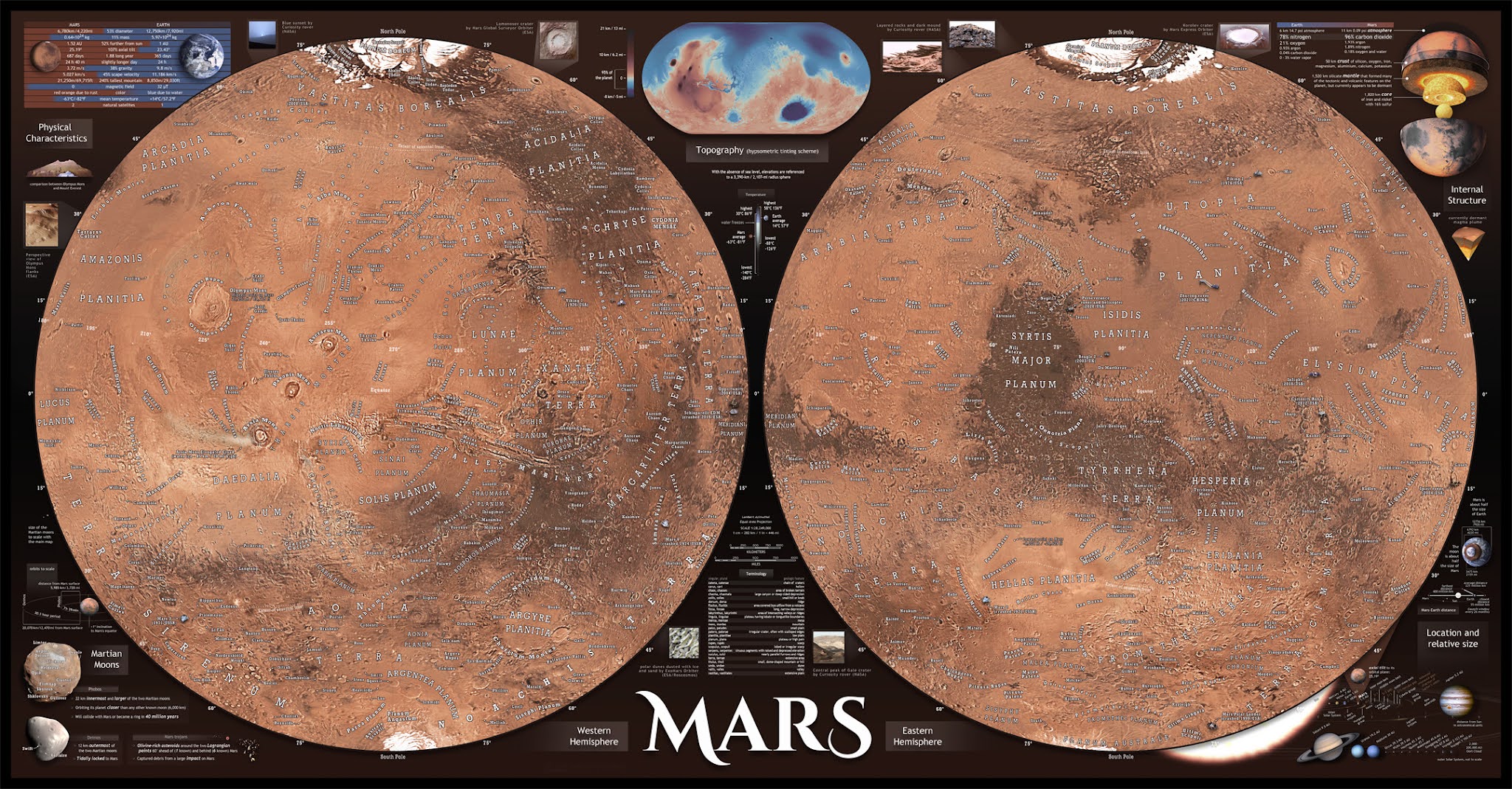
Very high resolution Map of Mars with labeled objects and data charts developed by our team in 2022.

High Quality Print Metal Plate HD Download
Zoom and explore the map here:bit.ly/planetmarsmap

